Category 5 Hurricane Milton now has sustained 180-mph winds, remains on course for Florida

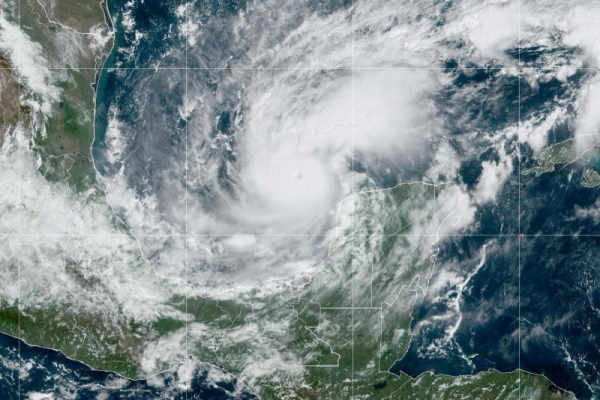
Hurricane Milton is projected to reach a Category 5 status Monday on track to make landfall along Florida’s west coast by Wednesday. Image courtesy of NOAA
Hurricane Milton, already a monster Category 5 storm, continued to strengthen on Monday and now packs sustained winds of 180 mph as it remains on course to make landfall on Florida’s west coast by Wednesday.
In its 4 p.m. CDT update, the National Hurricane Center placed Milton about 105 miles west-northwest of Progreso, Mexico, and about 700 miles west-southwest of Tampa, Fla. Advertisement
Earlier Monday, Milton’s wind speeds had increased by 90 mph in less than 24 hours. It’s now being called the third-fastest rapidly intensifying storm on record in the Atlantic, according to more than 40 years of National Hurricane Center data.
The storm is moving east-southeast at roughly 10 mph, but is expected to increase in speed, forecasters said.
Forecasters expect the storm to diminish slightly before landfall, yet it is expected to remain a potentially deadly Category 3 or 4 storm when it passes over the peninsula. It is expected to remain a Category 1 storm as it exits eastward into the Atlantic. Advertisement
A hurricane watch and tropical storm warning have been issued by the Mexican government in its Monday updates for south of Celestun to Campeche.
A hurricane warning was in effect for the coast of the Yucatan Peninsula of Mexico from Celestun to Rio Lagartos.
A hurricane watch was in effect for the coast of the Yucatan Peninsula of Mexico from Rio Lagartos to Cabo Catoche, Campeche to south of Celestun, then from the Florida Gulf Coast from Chokoloskee to the mouth of the Suwanee River, including Tampa Bay, Dry Tortugas and Lake Okeechobee.
A tropical storm warning was in effect for the coast of the Yucatan Peninsula of Mexico from Rio Lagartos to Cancun and Campeche to south of Celestun.
A tropical storm watch was in effect for the Florida Gulf Coast from Flamingo to South of Chokoloskee and the Florida Gulf coast north of the mouth of the Suwanee River to Indian Pass and * Lower, Middle, and Upper Florida Keys, including Florida Bay
A storm surge watch was in effect for the Flordia Gulf coast from Flamingo northward to the Suwannee River, including Charlotte Harbor and Tampa Bay.
“Milton is forecast to move just north of the Yucatan Peninsula and across the southern Gulf of Mexico today and Tuesday and approach the west coast of the Florida Peninsula by Wednesday,” the NHC said Monday. Advertisement
In a discussion on the storm, the NHC noted that Milton would strengthen over the weekend into a Category 4 hurricane, with winds between 130 and 156 mph.
While forecasters say it is too soon to specify the exact strength of the storm at landfall, or pinpoint its exact landfall location, the NHC warned of “an increasing risk of life-threatening storm surge and damaging winds for portions of the west coast of Florida,” beginning early Wednesday, with heavy rainfall to start Monday.
Portions of the Florida Peninsula and the Keys are to receive between 5 and 10 inches of rain, with some areas to receive up to 15 inches through Wednesday night, raising the risk of “considerable flash, urban and areal flooding,” the NHC said.
Meanwhile, Florida’s west coast has already been hit by two hurricanes this season.
Hurricane Helene hit the coast near Perry in the Big Bend Region on Sept. 26 as a Category 4 storm.
Hurricane Debby hit nearby Steinhatchee as a Category 1 storm on Aug. 5.
Milton, the 13th named storm of the Atlantic hurricane season, is one of three churning in the Atlantic, but is the only posing a threat to land. The other two are: Kirk, a Category 3 storm; and Leslie, which became a hurricane late Friday. Advertisement