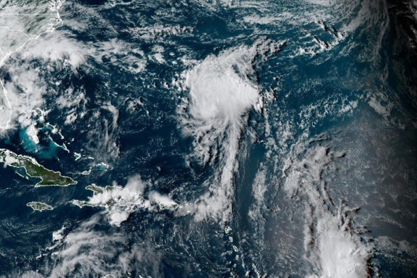
Tropical Storm Fernand becomes season’s sixth named storm
The storm is forecast to stay in open waters, the National Hurricane Center said


1 of 2 | Tropical Storm Ferdinand should move well east of Bermuda and across the open waters of the subtropical North Atlantic. Photo by National Oceanic and Atmospheric Administration.
The season’s sixth named storm, Tropical Storm Fernand, has formed in the tropical Atlantic Ocean but is not expected to make landfall before dying out next week.
The tropical storm had maximum sustained winds of 40 mph while located about 405 miles south-southeast of Bermuda and moving northerly at 15 mph, according to the National Hurricane Center’s 5 p.m. EDT advisory.
Tropical storm-force winds extend outward about 105 miles from the storm’s eye, and the NHC said it should gain strength.
Fernand might reach hurricane strength on Monday, before starting to weaken on Tuesday, NHC forecasters said.
No coastal watches are warnings are in effect, and the storm likely will remain at sea throughout its life.
Forecasters expect the storm system to gain forward momentum while continuing on a north-northeast path over the next couple of days and move well east of Bermuda before turning northeasterly into the North Atlantic.
The storm system began forming as Hurricane Eric affected areas along the East Coast without making landfall. The hurricane was the season’s first and briefly reached Category 4 status with maximum sustained winds of up to 150 mph.
Colorado State University climatologists in April predicted this year’s storm season will produce 17 named storms, including nine hurricanes.
The climatologists predicted four hurricanes would reach “major” Category 3 storm status with maximum sustained winds of at least 111 mph.
The annual Atlantic storm season runs from June 1 to Nov. 30 and last year produced 18 named storms, including 11 hurricanes, in 2024.
Five hurricanes became major hurricanes of Category 3 or higher, including the highly destructive Hurricanes Helene and Milton.