Typhoon Bolaven, a robust storm in the West Pacific basin, has been walloping the island territory of Guam and the Northern Mariana Islands this week, engulfing the islands in heavy rain and gusty winds.
Bolaven became a tropical storm Saturday about several hundred miles to the southeast of Guam. By Tuesday night, it was equivalent to a Category 1 hurricane on the Saffir-Simpson Wind Scale (maximum sustained winds of 74-95 mph). Advertisement
The National Weather Service office in Guam placed Tinian, Rota and Saipan coastal waters under a typhoon warning Tuesday into Wednesday, warning of extremely dangerous seas that can capsize, damage or destroy vessels and reduce visibility.
High seas of 20-24 feet are expected into Wednesday morning across the region.
On Tuesday, typhoon-force winds greater than 74 mph spread across Rota, Tinian, Saipan and Guam. By Tuesday night, local time, the core of Typhoon Bolaven was churning over the Northern Mariana Islands with outer rain bands reaching across Guam. Advertisement
A peak wind gust of 68 mph was recorded on Saipan Island, part of the Northern Mariana Islands, as Bolaven passed over the region Tuesday. Wind gusts of 46 mph were observed at Guam International Airport Tuesday as the center of Typhoon Bolaven passed roughly 50 miles northeast of the island.
Soaking rainfall will continue to spread across the islands through late Wednesday, which can lead to flash flooding in low-lying areas. Road closures, travel delays and structural damage can occur as this robust storm tracks to the northwest.
“Rainfall across Guam and the Northern Mariana Islands will be 4-8 inches,” AccuWeather lead international forecaster Jason Nicholls said.
|
|
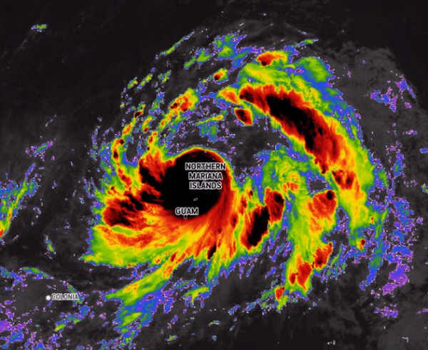
| Typhoon Bolaven as it tracks over Guam and the Northern Mariana Islands late Tuesday. Image courtesy of AccuWeather Enhanced RealVue Satellite |

From Monday evening to Tuesday evening, rainfall reports from Agana, Guam, reached nearly 4 inches. Nearby locations, such as Guam International Airport, observed upward of 2.13 inches on Tuesday alone.
Forecasters say strengthening is likely over the upcoming days as Bolaven tracks northwestward into midweek. Bolaven is expected to reach the maximum intensity of a Category 4 hurricane as it curves to the northeast later this week, parallel to Japan. Advertisement
The storm “should rapidly transition to an extra-tropical storm over the open North Pacific by Monday, local time. The forecast track will keep the storm east of the Ogasawara Islands on Friday, local time, and then well east of Japan this weekend,” Nicholls said.
The last notable West Pacific typhoon to impact Guam and the Northern Mariana Islands was Typhoon Mawar in May, which was the equivalent of a Category 4 hurricane (maximum sustained winds of 130-156 mph).
This monster of a storm brought peak winds of 149 mph across the islands during the last week of May, and the center of the storm tracked directly between Guam and Rota Island, part of the Marianas.
Nearly the entire island territory of Guam was without power after Typhoon Mawar impacted the region. At one point, less than 2% of customers across Guam had access to electricity, according to the Guam Power Authority.
Looking at the long-term track of Bolaven, AccuWeather meteorologists are concerned that the storm may eventually stir up trouble across the Gulf of Alaska late next week.
Bolaven “in the western Pacific can recurve, weaken, then intensify rapidly heading toward the Gulf of Alaska early to middle of next week,” said AccuWeather lead long-range forecaster Paul Pastelok. Advertisement
The storm’s impact on Alaska can eventually trickle down to influence the weather pattern along the West Coast of the United States.
“This could be a massive storm with high winds and heavy rain along the southern coast of Alaska. Seas will build across this region and can impact the U.S. West Coast. Snowfall in the southeastern mountains of Alaska and western Canada will be measured in feet,” Pastelok said.